I wrote before about the Curdridge Common Inclosure Map of 1856. That set me thinking that it might be interesting to look at other old maps of Curdridge to see what changes there have been.
The first map I found with any useful detail was Thomas Milne’s Map of Hampshire of 1791, surveyed at roughly one inch to the mile. (The coloured bands dissecting the map into three are parish boundaries).
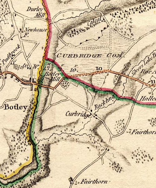
The first thing I noticed was that Curdridge is nowhere to be seen and Curdridge Common is instead attributed to Curbridge. Furthermore, Shawford’s Lake stream and the River Cur have been merged so that there’s only one tributary flowing into the Hamble on the map rather than the actual two. There are also two Fairthorn’s on the map – and neither of them are in the right place. At that time there was only Fairthorne Farm on the way to Curbidge.
However, those errors aside, if we can rely on the roads, we can see that the Botley to Kings Corner/Pinkmead road splits as now, one road down to Curbridge and beyond and the other to the top of Kitnocks Hill and on the way to Shedfield. The road which goes North-East from the top of Kitnocks Hill, along the edge of the Common until it meets another such road coming in from the left, must be what is now Lockhams Road. The road coming in from the left and the road carrying on to the top-right edge of the map is Curdridge Lane. The thing to notice is that there was no Bishops Waltham road at this time. Curdridge Lane, via Waltham Chase, was the only way to go. This was undoubtedly because Curdridge Lane skirts the boundary to the Bishop’s Deer Park – the Park Lug, unlike the later road, which runs more directly to Bishops Waltham by going straight through the Lug and across the Park. Calcot lane, Netherhill and Wangfield Lane seem to be present, but Durley Mill is not quite where it should be. It seems to me there may have been some confusion between Wangfield Lane and the end of Blind Lane/Breech Hill (off Calcot Lane).
Meanwhile, in the centre of the map, is Curdridge Common – and a couple of tracks across it. There seem to be some houses along its Northern edge and perhaps some down a misplaced Outlands Lane. There is certainly a cluster of buildings in Curbridge. Perhaps that cluster explains the lack of a Curdridge on the map. Perhaps at that time Curbridge was a more noticeable settlement – at the crossing of the River Cur – while Curdridge was just a scattering of dwellings around the edge of the wild and uncultivated Common.
Kevan Bundell