Curdridge Mapped – Ordnance Survey 6 inch map, 1868.

Curdridge Mapped – Ordnance Survey 6 inch map, 1868.

At last, Curdridge is given its correct name, rather than being labelled Curbridge as on earlier maps.

We can see immediately that the modern road layout is now in place – Reading Room Lane, Chapel Lane and the Southern end of Wangfield Lane have all been constructed since the OS 1810s-50s ‘Old Series’ map I wrote about earlier. What was a split track across part of the Common is now Outlands Lane, leaving a line of houses to the East marking where one of the tracks ran previously.

The current map is also later than the Curdridge Common Inclosure Map of 1856 that I wrote about earlier and we can see that what was the open Common has now been divided into a number of fields, much as they remain today.

St Peter’s Church on the map is the Chapel of Ease built in 1835. The present church was not built until 1887. The Plantation triangle is marked as a Recreation Ground, which indeed it was, created as part of the Inclosure. The present Reading Room Rec was not established until 1884. The present Cricketer’s pub was the Land of Promise and what looks like it might have been another pub, the Heart in Hand, was in fact the name of a farm, now the site of Curdridge Grange. A pond, which still exists, is marked beside the road.

Kitnocks house is at last labelled as such on this map whereas previously it had been called Curbridge House. Curdridge House is correctly located on the Bishops Waltham road, East of the Church. Fairthorn House – that is, Manor – is just off the map above but had now been built (in 1854). The estate entrance Lodge is marked. The original Fairthorn, a farm, is now named Fairthorn Grange, as it is still.

Interestingly, the Memorial Stone which is now at the Station is located on this map at what is now King’s Corner/Pinkmead Farm (labelled Botleyhill Farm on this map), whereas it was by the Station on the earlier ‘Old Series’ map. Was it moved and then moved back again for some reason ?

Unfortunately the map I have does not extend to Curbridge.

Kevan Bundell

Curdridge Mapped – Ordnance Survey 1810s-50s ‘Old Series’.

I wrote before about Thomas Milne’s Map of Hampshire of 1791, noting both the errors it contained and the familiar roads which were already there and those which weren’t. This 1 inch OS map has corrected most of the errors and shows more detail. It must have been last surveyed after 1840 because it shows the railway line and station which opened in that year. However, it is otherwise more or less the same as the OS map of 1831.

The one error it has in common with the older map is that it still names everything Curbridge. The name Curdridge is still nowhere to be seen. As before, the centre of the village is the Common, with a small cluster of buildings on what is now Church Lane, although no church is marked, even though the original Chapel of Ease was constructed in 1835. Otherwise, there are farms and other clusters on the lanes beyond the Common.


One cluster, to the South of the Common, is marked Curbridge House. This is where Kitnocks House now stands. Meanwhile, Curdridge House is nowadays a house on the Bishops Waltham road – probably marked by the single building to the North East of the churchless cluster. Does anyone know how or when the names changed ?

Most interestingly, there is a new road on the map – the Turnpike Road which runs from the top of the Common towards Harfield and beyond. This is the Bishops Waltham Road and provided a more direct route than having to go by Curdridge Lane via Waltham Chase. Also of note, a pond is marked on both sides of the road. This would have been used to provide drinking water for horses and to wash down both horses and carts. This, of course, is Cricketer’s Pond.

Reading Room Lane, Chapel Lane and the Southern end of Wangfield (Wamfield on the map) are yet to be constructed. Fairthorn on the map is what is now Fairthorne Grange – Fairthorne Manor was not built until 1854. Outlands Lane splits into two across the Common, and the Eastern track is still evidenced by the line of houses set back from the modern Lane – as, for example, in the case of Kitnocks Farm house.

The memorial stone at the station is marked. This is the stone ‘Erected to Perpetuate a Most Cruel Murder Commited on the Body of Thomas Webb a Poor Inhabitant of Swanmore on the 11th of February 1800’ which I wrote about some time ago. (Search: Curdridge local history).

Kevan Bundell

Curdridge mapped – Milne’s Hampshire, 1791.

I wrote before about the Curdridge Common Inclosure Map of 1856. That set me thinking that it might be interesting to look at other old maps of Curdridge to see what changes there have been.

The first map I found with any useful detail was Thomas Milne’s Map of Hampshire of 1791, surveyed at roughly one inch to the mile. (The coloured bands dissecting the map into three are parish boundaries).

The first thing I noticed was that Curdridge is nowhere to be seen and Curdridge Common is instead attributed to Curbridge. Furthermore, Shawford’s Lake stream and the River Cur have been merged so that there’s only one tributary flowing into the Hamble on the map rather than the actual two. There are also two Fairthorn’s on the map – and neither of them are in the right place. At that time there was only Fairthorne Farm on the way to Curbidge.

However, those errors aside, if we can rely on the roads, we can see that the Botley to Kings Corner/Pinkmead road splits as now, one road down to Curbridge and beyond and the other to the top of Kitnocks Hill and on the way to Shedfield. The road which goes North-East from the top of Kitnocks Hill, along the edge of the Common until it meets another such road coming in from the left, must be what is now Lockhams Road. The road coming in from the left and the road carrying on to the top-right edge of the map is Curdridge Lane. The thing to notice is that there was no Bishops Waltham road at this time. Curdridge Lane, via Waltham Chase, was the only way to go. This was undoubtedly because Curdridge Lane skirts the boundary to the Bishop’s Deer Park – the Park Lug, unlike the later road, which runs more directly to Bishops Waltham by going straight through the Lug and across the Park. Calcot lane, Netherhill and Wangfield Lane seem to be present, but Durley Mill is not quite where it should be. It seems to me there may have been some confusion between Wangfield Lane and the end of Blind Lane/Breech Hill (off Calcot Lane).

Meanwhile, in the centre of the map, is Curdridge Common – and a couple of tracks across it. There seem to be some houses along its Northern edge and perhaps some down a misplaced Outlands Lane. There is certainly a cluster of buildings in Curbridge. Perhaps that cluster explains the lack of a Curdridge on the map. Perhaps at that time Curbridge was a more noticeable settlement – at the crossing of the River Cur – while Curdridge was just a scattering of dwellings around the edge of the wild and uncultivated Common.

Kevan Bundell

The Inclosure of Curdridge Common, 1856.

Ordnance Survey maps call the fields between Chapel Lane and the Reading Room Rec Curdridge Common. I have never heard anyone use this name for these fields, but they are indeed part of what was Curdridge Common, which extended from Lockhams Road to the top of Station Hill, bounded, more or less, by the Bishops Waltham and Shedfield roads.

Some years ago, Dennis Stokes of the Botley and Curdridge Local History Society and I were sorting through the contents of the Reading Rooms safe when we came upon a copy of the Curdridge Common Inclosure Map 1856. It was rolled up in a long metal map case and measured about 3 by 5 feet. Attached to the map were pages listing the plots the Common was divided into and to whom they were given, sold or otherwise allocated. We deposited it, along with much else, at the Hampshire Records Office in Winchester.

Most villages had a common where locals could, for example, graze their family cow or their geese and collect fallen wood and furze for their fire. The common could make an important contribution to the livelihood of the poor. How important Curdridge Common was to anyone in 1856 – a relatively late date for inclosure – I don’t know. (Inclosure, by the way, is the legal term for the enclosure of common or ‘waste’ land).

Recently, I re-visited the Records Office to take a proper look at the Map and its attachments. I looked first for my property, at the bottom of Outlands Lane, but it was beyond the bounds of the map. However, the plot where Camper House now stands, about a third of way down the lane, was on the map and was listed as being owned by William Camper – who also built my house. He was one half of the famous yacht-building firm of Camper and Nicholson of Gosport.

Here are some of my other findings :

The Reading Rooms and Rec field went to ‘John Gatery’ of South Stoneham. In other words, it did not become a public space in 1856, and indeed the Reading Room Charity was only formed in 1884 when the land was bought for £945 by Sir Henry Jenkins of Botley and the Burrells of Fairthorne Manor for the purpose of providing the Reading Room and the Rec.

The Allotments/Rec field on the Bishops Waltham road went to the Churchwardens, who were responsible for the running and up-keep of the Parish Church. This would have been the Chapel of Ease, built in 1835. The present St Peter’s was not built until 1887, when the Chapel was demolished.

The Glebe field – beside the Church car park – went to the Churchwardens and to the Overseers of the Poor to support the National School, that is, the primary school, built in 1839. The Overseers – often the same people as the Churchwardens – were traditionally responsible for organising poor relief as part of the Poor Law system.

The triangle of land now between the Plantation and the Bishops Waltham road went to the Church Wardens for ‘exercise and recreation.’ This was the site of the original village cricket pitch – and the cottage beside the pond – Cricketer’s Pond -was the original Cricketer’s Pub.

The triangle of land between the B3051 and the A334 on the Botley side of the allotments/rec, plus the land on which Blenheim Cottage now sits at the top of Station Hill, went to the ‘Incumbent’, that is, to the Vicar, as a means of raising income, probably through renting the land out.

Meanwhile, Plot 28, which appears in the list of allocations but I couldn’t find on the Map, went to the Bishop of Winchester as ‘recompense for land lost’.

The Map also shows three ponds in the village. One is Cricketer’s Pond on the Bishops Waltham road, another is the pond now within the curtilage of Curdridge Grange – apparently known as Heart in Hand farm in 1856 – on Curdridge Lane. The third has vanished. It was located at ‘Wangfield Green’, that is, opposite Lower Wangfield Farm, near Frogmill Track on Wangfield Lane.

Kitcocks House, at the top of Kitnocks Hill, is named on the Map as Curdridge House, as it is on the OS map of 1868. Curdridge House is now the name of a fine old building on the Bishops Waltham road. I wonder if anyone knows how and why the name moved ?

Interestingly, despite the enclosure, a History of the County of Hampshire of 1908 reports that at that time ‘Curdridge Common’ consists of a few fields with patches of furze and heath, sloping up from the road opposite the church’. These fields are now thoroughly cultivated, but I wonder if remnants of the Common may not still exist. The green-winged orchids in the Glebe Field (there are some in the Rec too when they’re not mown), and the few furze/gorse bushes on Reading Room Lane could be such remnants. A botanist friend from the Wildlife Trust noticed a tiny, dwarfed heather plant in among the grass as we sat on the mowed lawn at Beechcroft. He could hardly contain his excitement at the possibility that this was also a remnant from the Common.

Does anyone else know of any possible remnants ?

Kevan Bundell
www.bundellbros.co.uk

St Peter’s Church and Sir Bevis of Hampton.

You may have noticed that the tower of St Peter’s Church is adorned around with a series of carvings of a variety of figures, some human, some animal. They are characters from the medieval legend of Sir Bevis of Hampton – i.e. of Southampton. Bevois Valley, south of Portswood, is named after him. The legend is long and complicated and if you want to know the details you can find them at https://historicsouthampton.co.uk/bevis/

 Meanwhile, it is not too difficult to match up the characters in the legend with the figures on the tower.

For a start, there’s Sir Bevis himself :   

And his horse Arondel :  


And the twins :  

and the boar :      and the lion :  

However, one of the figures is commonly said to be a character not from the Legend of Sir Bevis but rather from the local Curdridge ledgend of Kitty Knocks :

   This story tells of a young woman who drowned one night on Kitnocks Hill while trying to elope. I have written about this affair previously in the Parish News (see: https://bundellbros.co.uk/kevansmiscellany/category/kitnocks-kitty-nocks-curdridge-witch). I have even written a song about it, which you can listen to at https://www.youtube.com/watch?v=YyeD8Jf4KSU (at 18.56).

The question is, who was this character actually intended to be when they built the tower ? Was it meant to be Kitty Nocks, or was it meant to be another character from the Sir Bevis legend – Princess Josian, for example, Sir Bevis’s girlfriend ? In order to try and settle the matter, I headed off to the Hampshire Records Office in Winchester.

I found the papers – letters, documents, plans – relating to the building of St Peter’s Church in 1887. Unfortunately they had nothing to say about the tower, or its inhabitants.

It turns out that the tower was built some seven years later than the church itself – and there are no papers at all in the Records Office relating to the tower.

The mystery remains then. Is it Kitty Knocks, or is it not ?

Kevan Bundell – www.bundellbros.co.uk

Shawford’s Lake, Curdridge

It has long been a puzzle to me why the stream which runs by Lake Road/ Silverlake, through Kitnocks Gully and down through Fairthorne Manor to the Hamble, is called Shawford’s Lake. It is in fact a perennial stream of very modest dimensions. It’s certainly nothing like a lake.

But it’s not the only local stream that’s called a lake – there’s also Ford Lake which joins the Hamble at the junction of Wangfield Lane and Maddoxford Lane; and there’s Posbrook Lake which joins at the old slipway on Church Lane in Botley. Just before the Hamble joins the Solent, there’s a tributary called Hook Lake.

Some while ago, I happened to be perusing the Ordnance Survey map of the Solent. I noticed that many of the tidal channels in Portsmouth, Langstone and Chichester Harbours, are called lakes. The main channel of Portsmouth Harbour is fed, for example, by Fareham, Porchester, Spider and Bombketch Lakes. Langstone Harbour is similarly blessed with Broad, Russell’s and Sinah Lakes.

There was obviously a mystery here to be explored.

I consulted my friend David Chun, expert on and author of The River Hamble: A History.  It seems that the word lake has two different etymological origins. On the one hand, our usual and modern word lake comes, via French, from Latin lacus, meaning a lake, basin or tank. There is no suggestion there of a stream. However, the now dialect word used for our tributary streams and channels comes from Germanic Anglo Saxon lacu, meaning lake, pool and also stream. These words are of quite separate origin, but, unsurprisingly, they have become, over time, conflated and confused.

Puzzle solved.

However, another puzzle remains. Silverlake – which is not obviously silver nor a lake – derives its name from Anglo-Saxon Sulaford, which means ford of/at the boggy place. It was a ford on the important road from Botley, through Curdridge, to Shedfield and on to Wickham – before it was bridged – or rather, culverted. As Anglo-Saxon gave way to Middle and so to Modern English, Sula became silver and ford was replaced with lake, referring to the stream. But then how, why and when did it then become Shawford’s Lake ?


Kevan Bundell

www.bundellbros.co.uk


The history of Tanglewood

With the arrival of the modern Land Registry, old title deeds have become superfluous and are often simply thrown away when properties come to be sold. Fortunately, our solicitor saved the deeds for us when we moved into Tanglewood and I spent several weeks’ worth of winter evenings trying to unravel the history of the house and its land.

The older papers ‑ the earliest dated 5th July 1853 ‑ are beautifully handwritten documents on thick waxed paper with elaborately scripted titles. Two are written on printed engrossment paper and are sealed at the bottom with wax. From 1925, however, the papers are typed and full of errors and obvious failures to understand what was being copied. The art and experience of the legal clerk had gone.

Among the documents is an “Abstract of Title”, dated 6th August 1883. It begins with a summary of the Will of the 15th March 1862 of one William Camper, concerning, “All those two cottages and premises then lately erected and built by him … with the land and farm buildings thereon and adjoining thereto”. The original building was it seems a pair of two up two down “cottages”, both since substantially extended, one of which, has now become Tanglewood.

“William Camper of Gosport in the parish of Alverstoke in the County of Southampton, Shipbuilder” was one of the founders of the now world-famous yacht-builders firm of Camper and Nicholsons, still based in Gosport. In 1809 the young William Camper was apprenticed for a period of seven years to Francis Amos, a former ferry‑man between Gosport and Portsmouth who had turned to boat building near the ferry steps in 1783. At the age of about thirty‑five Camper took over the shipyard, presumably on the death of Amos, and in the following years built up with his partner Benjamin Nicholson, such a profitable business that he not only became wealthy but also earned himself the status of “Gentry” in the local Post Office Directory.

He seems to have bought the plot of land which has now become Tanglewood in about 1857 and he must have had the cottages built sometime between then and March 1862, the date of his Will. He also seems to have had built a couple of other properties nearby, further along the lane, including a modest Victorian villa which is still called “Camper House”.

When William Camper died in 1863 the land and cottages went to his daughter Mary. Unfortunately, things then appear not to have gone well. Between 1872 and 1883, when Mary died, “various dealings” with a number of individuals resulted in the ownership of the property being divided into three shares, two owned by two of Mary’s four sons and one by a Henry Morton Cotton. It looks as though the other two brothers, and possibly Mary’s second husband, John Earl, had used their shares to raise loans which they failed to repay.

Given this situation the two remaining brothers presumably had no choice but to sell the property. It was sold on the 6th August 1883 to Robert Anthony Burrell of Fairthorne and Augusta Burrell, Spinster, his sister, for the sum of £850.

The Burrells were from a wealthy mine‑owning family from Durham and had come down in 1878 and bought the 120 acre Fairthorne Estate, one boundary of which lay adjacent or close to Camper’s land. There is no record of what they did with the cottages and land but it may have been used to house some of the estate staff. Other houses nearby were especially built by Augusta Burrell for this purpose.

Robert Burrell died in 1910 and his sister, after a long life of local philanthropy, died in 1924. In 1925 the Fairthorne estate was sold by Augusta Burrell’s executors. What had been Camper’s cottages and land was sold to one George William Jupe, Farmer, on the 16th September of that year, for the sum of £1,250. In fact, George Jupe had already been occupying the cottage and land since the 1900’s. This is not stated in the documents, but Alf Mears, who was born in one of the Fairthorne staff cottages in 1912 and then lived in another, told me that it was certainly the case. At one time, said Mr Mears, Jupe courted his Aunt, but nothing came of it and Jupe remained a bachelor. He lived in the cottage with a housekeeper, who kept a small shop in the front room, and her daughter.

What Mr Mears did not know, but the documents reveal, is that in order to buy the property Mr Jupe had borrowed a substantial sum of money. On the day after the sale he mortgaged the entire property to one Allan Bowes Wilson of Hutton Rudby, Yorks, for £1000. Wilson was clearly a relative ‑ perhaps the father or brother ‑ of Augusta Burrell’s solictor John George Wilson of the Durham firm of Wilson, Ornsby and Cadle. Unfortunately, it seems that Jupe was never able to repay the loan. Mr Mears recalls that some time before the war Jupe moved out of the cottage and went to live in a shack on another piece of land that he owned or rented in the village. When I told Mr Mears about the mortgage and how much Jupe had paid for the property he replied that Jupe had been a fool and the property never worth so much.

Jupe must have moved out within a few years because by 1930 the cottage and land were occupied and run as a smallholding by William George and Dorothy Rose Pink. It was during this time that the property at last acquired a name. Although the property had become known informally as Pink’s Farm, when the registration of smallholdings was required, it was named “Field View”, borrowing the already existing name of the other half of the cottage.

The Pinks remained in Field View – or Pink’s farm – until 1971, a year or two after William Pink had died, and the following year Edmund Luxmore, the final heir to the Jupe mortgage, sold the property to our immediate predecessors, who both modernised and extended the house and gave it the name “Tanglewood”.

The deeds of the property now end with some papers relating to our purchase of Tanglewood in the summer of 1993, taking us to modern times. As mentioned earlier, the oldest document dates to 1853, so the deeds now cover one hundred and forty years of our home’s history. However, after some time and study I discovered that the deeds actually take us a great deal further back than the 1850’s – as far back, in fact, as the fourteenth century.

The fields which are now Tanglewood were formerly part of the lands of Bishops Waltham Manor. In 1925, the same year that George Jupe purchased the property from the Fairthorne Estate, the copyhold rights of the Ecclesiastical Commissioners, “Lords of the said Manor of Bishops Waltham”, were “enfranchised and conveyed ……. in fee simple as freehold henceforth and for ever discharged from all fines quit rents heriots and other incidents of copyhold tenure”. In other words, the land became freehold and the Manor’s rights over the property were abolished. Prior to that, however, whenever the property was sold the new owner had to be ‘admitted’ by the payment of a ‘fine’ to the court of the Manor. Among the papers we inherited with the house and land is a copy of a document giving such admission, with the original dated November 1864. The document lists and describes not only Tanglewood but also other adjacent and nearby plots of land. The description of one of these reads as follows:

“…. by estimation ten acres of land now called Outlands formerly Isold in the tithing of Curdridge in six closes now divided under the yearly rent of 1s being late parcel of one messuage and one yard of Boudland and one toft and half a yard of Boudland formerly Isold at Park and other premises ….”

The word “Isold” was a puzzle to me. The other unfamiliar words were in the dictionary ‑ a messuage is a dwelling with its outbuildings and attached land; a toft is a dwelling with attached rights to use common land and “Boudland” is presumably “bondland”, a holding where the tenant was obliged to render some kind of services at harvest and at ploughing time to the Lord of the Manor. “Isold”, however, was not in the dictionary.

At first sight, except for the capitals, it appeared to be a verb ‑ something which had happened or been done to the land ‑ but without knowing what it might mean I had some doubt. It was only when my neighbour, a local historian, handed me a copy of the “1332 and 1464 Rentals of the Manors of Bishops Waltham”, translated from the Latin originals by Harold Barstow, (1992), that the mystery was solved. There in the list of tenants and their holdings for 1464 I found, “ISOLDA daughter of the late Andrew at Park”. I realised immediately that I had been missing the clue given by the word “formerly”. This is in fact always used in the documents – as standard legal usage – to refer to a previous owner. Isolda at Park had managed to survive centuries of intervening tenancies and continue to appear on the court’s description of the land ‑ a medieval landholder in a nineteenth century document.

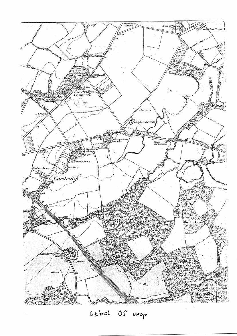
Isolda’s name first appears on the list of 1332, although it was only added at some later and unspecified time when the list was updated. She is shown as having succeeded one Andrew le Thatchare to “one cottage in purpresture” ‑ that is, a cottage built by encroaching on a public road or track. By 1464, however, she had become a more substantial landholder and is recorded as having four tenancies scattered throughout the southern part of the tithing of Curdridge.   It then became clear from a sketch map prepared by E.M. Stevenson on the basis of Harold Barstow’s translation (“Curdridge in 1464”, Hampshire Field Club,1993) that one of her holdings included the land now occupied by Tanglewood (look for Q3) :

The medieval documents show that Isolda’s predecessors to the holdings were also at Parks. One tenancy was previously held by her father Andrew; the other three were previously held by one Peter at Park ‑ perhaps her uncle or her brother. Peter in turn had been preceded by Roger at Park in one case and by Robert at Park in another. The third holding appears to have been the one already mentioned above as having come from Andrew le Thatchare. One of Peter’s holdings had earlier been held by Thomas and Margaret at Park, as indeed had the holding Isolda presumably inherited from her father. By 1464, however, there are no other at Park’s listed as tenants not only in the tithing of Curdridge but anywhere on the Manor’s lands. The question is, where had the family gone?

The Black Death swept England in 1348‑49 and decimated whole villages. However, that would seem too early to explain why only Isolda seems to have remained by 1464 when there were clearly other at Parks alive in the intervening years. On the other hand, rates of mortality, particularly among mothers and infants, were high enough in the fourteenth and fifteenth centuries irrespective of the plague and perhaps this is the reason not only for the absence of other at Parks but also why Isolda inherited from Peter at Park as well as her father, Andrew. Her name survived in the documents, I believe, because she was the first tenant to be written down and recorded in the court’s lists. This record therefore became part of the defining description of the holding as it passed from tenant to tenant across the centuries.

*

The History of Tanglewood – Part 2

Since I wrote the above, new evidence has come to light about the original form of the house built for William camper in 1860 (or thereabouts). It seems that the original house may in fact have been one – not two.

William Camper’s Will of the 15th March 1862 says “All those two cottages and premises then lately erected and built by him … with the land and farm buildings thereon and adjoining thereto”. I concluded from this that the original building was a pair of two up two down “cottages”. However, Flem and Edna Alison – from whom we bought Tanglewood – have always begged to differ. Having rebuilt half the house, and added to it, in the early ‘70s, they maintained that it was originally built as one house. This would explain the clear presence of a bricked-up doorway in the middle of the front elevation – which was always a puzzle.

Last year we had a downstairs bathroom created between our downstairs bedroom at the front and the back room behind. That is, between the front and back rooms of the old part of the building. We made some interesting discoveries.

Firstly, we unburied a short brick path running parallel with and between the two rooms. Christina from up the road, whose grandparents had lived in the house (the Pinks), confirmed that this was the floor of the cellar under the stairs – which also served as the air-raid shelter during the war.

Secondly, our builders happened to expose a patch of the rear wall of our bedroom, the front room. The patterned brickwork revealed clearly matched the brickwork of the original outside walls elsewhere. That is, this must once also have been an exterior wall and the original house must only have been one room deep – two downstairs and two upstairs. The rooms behind and the division of the house must have come later.

I can speculate when.  During George Jupe’s time the house was as it had been built and his housekeeper’s shop in one of the front rooms (which then sported a bay window) was accessed by the front door. After the property was repossessed – and before the Pink’s moved in ? – the house was divided and more rooms added at the back. Unfortunately, the only witness I could have checked this with, David Mears, who told me about Jupe and his housekeeper, is no longer with us.

So what are we to make of William Camper’s Will saying “those two cottages lately built” ? If the original Tanglewood was one, where’s the other ? My guess is that it might refer to the semis up the lane which sit beside Camper House. I had a word with the current occupant of one of the two and he was of the opinion that the house was once one. If so, then either another house was added beside the original, or, as in the case of Tanglewood, a single dwelling was subsequently rent asunder.

2024

Curdridge and Curbridge – the same or different ?


                 Curdridge                                                       Curbridge

I have often wondered whether the two Curs in our parish[1] are the same or different. That is, are they of same etymological origin, or are they just an historical coincidence ?

The first thing I noticed when I began to explore this mystery is that the first edition of the Ordnance Survey 1 inch map of South Hampshire solved the problem by deciding that they were one and the same. According to the map there is no such place as Curdridge. Everything is labelled Curbridge – not only Curbridge itself, but also Curbridge Common (the fields from the top of Station Hill to Lockhams Road, Curdridge Lane and The Plantation) and Curbridge House (now Kitnocks House at the top of Kitnocks Hill). They should, of course, be Curdridge Common and Curdridge House. Either the surveyors got confused or maybe someone in the office decided that the surveyors had made a spelling mistake. Fortunately, this was all corrected in later editions.

The next thing I did was e-mail my friend, and local historian, David Chun. He has written a fine book on the history of the River Hamble and its surrounds so I thought I’d ask what he knew about Curdridge and Curbridge. He advised me that he had read that ‘place name interpretation is complex, and not something that an amateur should dabble in!’

However, he also referred me to ‘The Place-Names of Hampshire’ by Richard Coates (1989). He then pointed out that there was a copy available on Amazon for 79p. I bought it at once. The postage was a good bit more of course, but still, it was a good purchase: it answered my question.

Curdridge originates from an Anglo-Saxon name meaning Cuthred’s ridge. In other words, some chap called Cuthred ‘owned’ or had otherwise been granted possession of what we now know as the village of Curdridge, which lies – largely – on a ridge.

Curbridge, meanwhile, was variously known – or at least spelt –as Kernebrugge, Kerebrigge, Kernebregge and Cornebrigge. These names – or spellings – do not obviously have any connection to our man Cuthred. The common cur component in the two village names is, it would seem, a coincidence.

But then there is another mystery. Mr Coates is not at all sure what the meaning of Curbridgde’s Kerne, etc, might in fact be. He is convinced on historical-linguistic grounds that it comes from the Anglo-Saxon for quern – that is, the lower stone of a hand-driven grinding mill, once a common domestic item. He is then understandably unconvinced that anyone would try to build a bridge over a river with a collection of quern-stones. It is, he says, a question he prefers to leave open.

One possibility, of course, is that kern does not refer to – or describe – the bridge, but was, as it is now, the name of the river. But then why would you name a river after a grinding stone ?

My reluctant conclusion is that what David said is right and that this is not the sort of thing an amateur should dabble in.


Kevan Bundell

  1. The Parish is Curdridge, of which Curbridge is a hamlet.

Frog Mill or Paper Mill ?

Frog Mill or Paper Mill ?

A few months ago I mentioned in the Parish News that Frogmill Track – off Wangfield Lane – is so-called because it leads, by footpath, to the now derelict Frog Mill. This was a paper mill, not a corn mill. Rumour says that it used to make paper for Bank of England bank notes, or for the Morning Post newspaper. After my comment appeared I received a phone call from Miss Katherine Stone, formerly of `The Elms’, Outlands Lane, now living in Botley. She was keen to tell me that the correct name of the mill is Paper Mill, not Frog Mill. Her grandfather lived there and always called it by that name.

Here was a mystery. It is certainly known as Frog Mill, or Frogmill, nowadays, and is named as such on OS maps. But even within living memory it was also, it seems, known as Paper Mill. I immediately contacted Dennis Stokes of the Botley and Curdridge Local history Society to see if he could help solve the conundrum. He sent me a paper from the Society’s archives, researched and written by John Hammond , which tells the following story :

Just a quarter of a mile upstream from Frog/Paper Mill sits Durley Mill. In the 12th, 13th and 14th centuries this mill was owned by a family called Frogge. Furthermore the deeds of this mill called it `Frogmill’ right up to the 20th century. Our mill, meanwhile, was, from its earliest record, in 1648, `called a Papermill’ and it was not until 1738 that it is first referred to as Frog Mill. By 1834 it is clearly referred to as `a paper mill known as Frogmill’.

There was obviously some confusion over the centuries and the name Frog transferred from Durley Mill to the Paper Mill, despite the name Frogge remaining on the former’s deeds. John Hammond suggests that Durley Mill `was, no doubt, referred to generally by the name of whoever the owner at that time might be’. This would explain at least why it lost the Frog name over time, leaving the name free to float downstream.

By 1862 Paper Mill was, according to its deeds, `long since disused’, although people continued to live in its associated cottage. John Hammond reports that Jesse Bannell (who was Ms Stone’s Grandfather) and his family lived there from 1871 until at least 1891 and that Walter Henry Elliott and family lived there from 1901 until the 1920s. By 1938 the cottage was no longer occupied and by 1965 the building were all derelict.

It remains a minor mystery how it was that while everyone else followed the confusing of the names and mills, those who lived there still knew very well that the `correct’ name was in fact Paper Mill. We must thank Miss Stone for keeping this knowledge alive.

Kevan Bundell

11.08.15