Curdridge Mapped – Ordnance Survey 6 inch map, 1868.

Curdridge Mapped – Ordnance Survey 6 inch map, 1868.

At last, Curdridge is given its correct name, rather than being labelled Curbridge as on earlier maps.

We can see immediately that the modern road layout is now in place – Reading Room Lane, Chapel Lane and the Southern end of Wangfield Lane have all been constructed since the OS 1810s-50s ‘Old Series’ map I wrote about earlier. What was a split track across part of the Common is now Outlands Lane, leaving a line of houses to the East marking where one of the tracks ran previously.

The current map is also later than the Curdridge Common Inclosure Map of 1856 that I wrote about earlier and we can see that what was the open Common has now been divided into a number of fields, much as they remain today.

St Peter’s Church on the map is the Chapel of Ease built in 1835. The present church was not built until 1887. The Plantation triangle is marked as a Recreation Ground, which indeed it was, created as part of the Inclosure. The present Reading Room Rec was not established until 1884. The present Cricketer’s pub was the Land of Promise and what looks like it might have been another pub, the Heart in Hand, was in fact the name of a farm, now the site of Curdridge Grange. A pond, which still exists, is marked beside the road.

Kitnocks house is at last labelled as such on this map whereas previously it had been called Curbridge House. Curdridge House is correctly located on the Bishops Waltham road, East of the Church. Fairthorn House – that is, Manor – is just off the map above but had now been built (in 1854). The estate entrance Lodge is marked. The original Fairthorn, a farm, is now named Fairthorn Grange, as it is still.

Interestingly, the Memorial Stone which is now at the Station is located on this map at what is now King’s Corner/Pinkmead Farm (labelled Botleyhill Farm on this map), whereas it was by the Station on the earlier ‘Old Series’ map. Was it moved and then moved back again for some reason ?

Unfortunately the map I have does not extend to Curbridge.

Kevan Bundell

Curdridge Mapped – Ordnance Survey 1810s-50s ‘Old Series’.

I wrote before about Thomas Milne’s Map of Hampshire of 1791, noting both the errors it contained and the familiar roads which were already there and those which weren’t. This 1 inch OS map has corrected most of the errors and shows more detail. It must have been last surveyed after 1840 because it shows the railway line and station which opened in that year. However, it is otherwise more or less the same as the OS map of 1831.

The one error it has in common with the older map is that it still names everything Curbridge. The name Curdridge is still nowhere to be seen. As before, the centre of the village is the Common, with a small cluster of buildings on what is now Church Lane, although no church is marked, even though the original Chapel of Ease was constructed in 1835. Otherwise, there are farms and other clusters on the lanes beyond the Common.


One cluster, to the South of the Common, is marked Curbridge House. This is where Kitnocks House now stands. Meanwhile, Curdridge House is nowadays a house on the Bishops Waltham road – probably marked by the single building to the North East of the churchless cluster. Does anyone know how or when the names changed ?

Most interestingly, there is a new road on the map – the Turnpike Road which runs from the top of the Common towards Harfield and beyond. This is the Bishops Waltham Road and provided a more direct route than having to go by Curdridge Lane via Waltham Chase. Also of note, a pond is marked on both sides of the road. This would have been used to provide drinking water for horses and to wash down both horses and carts. This, of course, is Cricketer’s Pond.

Reading Room Lane, Chapel Lane and the Southern end of Wangfield (Wamfield on the map) are yet to be constructed. Fairthorn on the map is what is now Fairthorne Grange – Fairthorne Manor was not built until 1854. Outlands Lane splits into two across the Common, and the Eastern track is still evidenced by the line of houses set back from the modern Lane – as, for example, in the case of Kitnocks Farm house.

The memorial stone at the station is marked. This is the stone ‘Erected to Perpetuate a Most Cruel Murder Commited on the Body of Thomas Webb a Poor Inhabitant of Swanmore on the 11th of February 1800’ which I wrote about some time ago. (Search: Curdridge local history).

Kevan Bundell

Curdridge mapped – Milne’s Hampshire, 1791.

I wrote before about the Curdridge Common Inclosure Map of 1856. That set me thinking that it might be interesting to look at other old maps of Curdridge to see what changes there have been.

The first map I found with any useful detail was Thomas Milne’s Map of Hampshire of 1791, surveyed at roughly one inch to the mile. (The coloured bands dissecting the map into three are parish boundaries).

The first thing I noticed was that Curdridge is nowhere to be seen and Curdridge Common is instead attributed to Curbridge. Furthermore, Shawford’s Lake stream and the River Cur have been merged so that there’s only one tributary flowing into the Hamble on the map rather than the actual two. There are also two Fairthorn’s on the map – and neither of them are in the right place. At that time there was only Fairthorne Farm on the way to Curbidge.

However, those errors aside, if we can rely on the roads, we can see that the Botley to Kings Corner/Pinkmead road splits as now, one road down to Curbridge and beyond and the other to the top of Kitnocks Hill and on the way to Shedfield. The road which goes North-East from the top of Kitnocks Hill, along the edge of the Common until it meets another such road coming in from the left, must be what is now Lockhams Road. The road coming in from the left and the road carrying on to the top-right edge of the map is Curdridge Lane. The thing to notice is that there was no Bishops Waltham road at this time. Curdridge Lane, via Waltham Chase, was the only way to go. This was undoubtedly because Curdridge Lane skirts the boundary to the Bishop’s Deer Park – the Park Lug, unlike the later road, which runs more directly to Bishops Waltham by going straight through the Lug and across the Park. Calcot lane, Netherhill and Wangfield Lane seem to be present, but Durley Mill is not quite where it should be. It seems to me there may have been some confusion between Wangfield Lane and the end of Blind Lane/Breech Hill (off Calcot Lane).

Meanwhile, in the centre of the map, is Curdridge Common – and a couple of tracks across it. There seem to be some houses along its Northern edge and perhaps some down a misplaced Outlands Lane. There is certainly a cluster of buildings in Curbridge. Perhaps that cluster explains the lack of a Curdridge on the map. Perhaps at that time Curbridge was a more noticeable settlement – at the crossing of the River Cur – while Curdridge was just a scattering of dwellings around the edge of the wild and uncultivated Common.

Kevan Bundell

The Inclosure of Curdridge Common, 1856.

Ordnance Survey maps call the fields between Chapel Lane and the Reading Room Rec Curdridge Common. I have never heard anyone use this name for these fields, but they are indeed part of what was Curdridge Common, which extended from Lockhams Road to the top of Station Hill, bounded, more or less, by the Bishops Waltham and Shedfield roads.

Some years ago, Dennis Stokes of the Botley and Curdridge Local History Society and I were sorting through the contents of the Reading Rooms safe when we came upon a copy of the Curdridge Common Inclosure Map 1856. It was rolled up in a long metal map case and measured about 3 by 5 feet. Attached to the map were pages listing the plots the Common was divided into and to whom they were given, sold or otherwise allocated. We deposited it, along with much else, at the Hampshire Records Office in Winchester.

Most villages had a common where locals could, for example, graze their family cow or their geese and collect fallen wood and furze for their fire. The common could make an important contribution to the livelihood of the poor. How important Curdridge Common was to anyone in 1856 – a relatively late date for inclosure – I don’t know. (Inclosure, by the way, is the legal term for the enclosure of common or ‘waste’ land).

Recently, I re-visited the Records Office to take a proper look at the Map and its attachments. I looked first for my property, at the bottom of Outlands Lane, but it was beyond the bounds of the map. However, the plot where Camper House now stands, about a third of way down the lane, was on the map and was listed as being owned by William Camper – who also built my house. He was one half of the famous yacht-building firm of Camper and Nicholson of Gosport.

Here are some of my other findings :

The Reading Rooms and Rec field went to ‘John Gatery’ of South Stoneham. In other words, it did not become a public space in 1856, and indeed the Reading Room Charity was only formed in 1884 when the land was bought for £945 by Sir Henry Jenkins of Botley and the Burrells of Fairthorne Manor for the purpose of providing the Reading Room and the Rec.

The Allotments/Rec field on the Bishops Waltham road went to the Churchwardens, who were responsible for the running and up-keep of the Parish Church. This would have been the Chapel of Ease, built in 1835. The present St Peter’s was not built until 1887, when the Chapel was demolished.

The Glebe field – beside the Church car park – went to the Churchwardens and to the Overseers of the Poor to support the National School, that is, the primary school, built in 1839. The Overseers – often the same people as the Churchwardens – were traditionally responsible for organising poor relief as part of the Poor Law system.

The triangle of land now between the Plantation and the Bishops Waltham road went to the Church Wardens for ‘exercise and recreation.’ This was the site of the original village cricket pitch – and the cottage beside the pond – Cricketer’s Pond -was the original Cricketer’s Pub.

The triangle of land between the B3051 and the A334 on the Botley side of the allotments/rec, plus the land on which Blenheim Cottage now sits at the top of Station Hill, went to the ‘Incumbent’, that is, to the Vicar, as a means of raising income, probably through renting the land out.

Meanwhile, Plot 28, which appears in the list of allocations but I couldn’t find on the Map, went to the Bishop of Winchester as ‘recompense for land lost’.

The Map also shows three ponds in the village. One is Cricketer’s Pond on the Bishops Waltham road, another is the pond now within the curtilage of Curdridge Grange – apparently known as Heart in Hand farm in 1856 – on Curdridge Lane. The third has vanished. It was located at ‘Wangfield Green’, that is, opposite Lower Wangfield Farm, near Frogmill Track on Wangfield Lane.

Kitcocks House, at the top of Kitnocks Hill, is named on the Map as Curdridge House, as it is on the OS map of 1868. Curdridge House is now the name of a fine old building on the Bishops Waltham road. I wonder if anyone knows how and why the name moved ?

Interestingly, despite the enclosure, a History of the County of Hampshire of 1908 reports that at that time ‘Curdridge Common’ consists of a few fields with patches of furze and heath, sloping up from the road opposite the church’. These fields are now thoroughly cultivated, but I wonder if remnants of the Common may not still exist. The green-winged orchids in the Glebe Field (there are some in the Rec too when they’re not mown), and the few furze/gorse bushes on Reading Room Lane could be such remnants. A botanist friend from the Wildlife Trust noticed a tiny, dwarfed heather plant in among the grass as we sat on the mowed lawn at Beechcroft. He could hardly contain his excitement at the possibility that this was also a remnant from the Common.

Does anyone else know of any possible remnants ?

Kevan Bundell
www.bundellbros.co.uk

St Peter’s Church and Sir Bevis of Hampton.

You may have noticed that the tower of St Peter’s Church is adorned around with a series of carvings of a variety of figures, some human, some animal. They are characters from the medieval legend of Sir Bevis of Hampton – i.e. of Southampton. Bevois Valley, south of Portswood, is named after him. The legend is long and complicated and if you want to know the details you can find them at https://historicsouthampton.co.uk/bevis/

 Meanwhile, it is not too difficult to match up the characters in the legend with the figures on the tower.

For a start, there’s Sir Bevis himself :   

And his horse Arondel :  


And the twins :  

and the boar :      and the lion :  

However, one of the figures is commonly said to be a character not from the Legend of Sir Bevis but rather from the local Curdridge ledgend of Kitty Knocks :

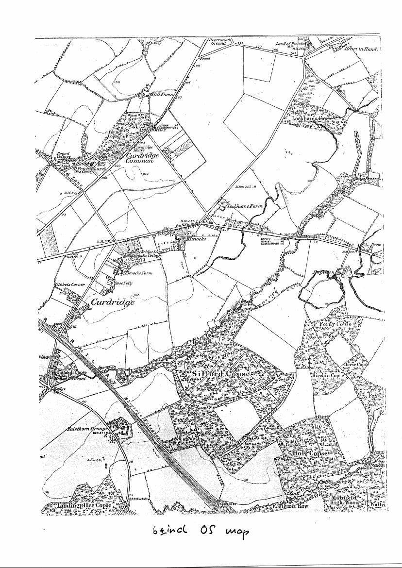
   This story tells of a young woman who drowned one night on Kitnocks Hill while trying to elope. I have written about this affair previously in the Parish News (see: https://bundellbros.co.uk/kevansmiscellany/category/kitnocks-kitty-nocks-curdridge-witch). I have even written a song about it, which you can listen to at https://www.youtube.com/watch?v=YyeD8Jf4KSU (at 18.56).

The question is, who was this character actually intended to be when they built the tower ? Was it meant to be Kitty Nocks, or was it meant to be another character from the Sir Bevis legend – Princess Josian, for example, Sir Bevis’s girlfriend ? In order to try and settle the matter, I headed off to the Hampshire Records Office in Winchester.

I found the papers – letters, documents, plans – relating to the building of St Peter’s Church in 1887. Unfortunately they had nothing to say about the tower, or its inhabitants.

It turns out that the tower was built some seven years later than the church itself – and there are no papers at all in the Records Office relating to the tower.

The mystery remains then. Is it Kitty Knocks, or is it not ?

Kevan Bundell – www.bundellbros.co.uk

Shawford’s Lake, Curdridge

It has long been a puzzle to me why the stream which runs by Lake Road/ Silverlake, through Kitnocks Gully and down through Fairthorne Manor to the Hamble, is called Shawford’s Lake. It is in fact a perennial stream of very modest dimensions. It’s certainly nothing like a lake.

But it’s not the only local stream that’s called a lake – there’s also Ford Lake which joins the Hamble at the junction of Wangfield Lane and Maddoxford Lane; and there’s Posbrook Lake which joins at the old slipway on Church Lane in Botley. Just before the Hamble joins the Solent, there’s a tributary called Hook Lake.

Some while ago, I happened to be perusing the Ordnance Survey map of the Solent. I noticed that many of the tidal channels in Portsmouth, Langstone and Chichester Harbours, are called lakes. The main channel of Portsmouth Harbour is fed, for example, by Fareham, Porchester, Spider and Bombketch Lakes. Langstone Harbour is similarly blessed with Broad, Russell’s and Sinah Lakes.

There was obviously a mystery here to be explored.

I consulted my friend David Chun, expert on and author of The River Hamble: A History.  It seems that the word lake has two different etymological origins. On the one hand, our usual and modern word lake comes, via French, from Latin lacus, meaning a lake, basin or tank. There is no suggestion there of a stream. However, the now dialect word used for our tributary streams and channels comes from Germanic Anglo Saxon lacu, meaning lake, pool and also stream. These words are of quite separate origin, but, unsurprisingly, they have become, over time, conflated and confused.

Puzzle solved.

However, another puzzle remains. Silverlake – which is not obviously silver nor a lake – derives its name from Anglo-Saxon Sulaford, which means ford of/at the boggy place. It was a ford on the important road from Botley, through Curdridge, to Shedfield and on to Wickham – before it was bridged – or rather, culverted. As Anglo-Saxon gave way to Middle and so to Modern English, Sula became silver and ford was replaced with lake, referring to the stream. But then how, why and when did it then become Shawford’s Lake ?


Kevan Bundell

www.bundellbros.co.uk


Curdridge and Curbridge – the same or different ?


                 Curdridge                                                       Curbridge

I have often wondered whether the two Curs in our parish[1] are the same or different. That is, are they of same etymological origin, or are they just an historical coincidence ?

The first thing I noticed when I began to explore this mystery is that the first edition of the Ordnance Survey 1 inch map of South Hampshire solved the problem by deciding that they were one and the same. According to the map there is no such place as Curdridge. Everything is labelled Curbridge – not only Curbridge itself, but also Curbridge Common (the fields from the top of Station Hill to Lockhams Road, Curdridge Lane and The Plantation) and Curbridge House (now Kitnocks House at the top of Kitnocks Hill). They should, of course, be Curdridge Common and Curdridge House. Either the surveyors got confused or maybe someone in the office decided that the surveyors had made a spelling mistake. Fortunately, this was all corrected in later editions.

The next thing I did was e-mail my friend, and local historian, David Chun. He has written a fine book on the history of the River Hamble and its surrounds so I thought I’d ask what he knew about Curdridge and Curbridge. He advised me that he had read that ‘place name interpretation is complex, and not something that an amateur should dabble in!’

However, he also referred me to ‘The Place-Names of Hampshire’ by Richard Coates (1989). He then pointed out that there was a copy available on Amazon for 79p. I bought it at once. The postage was a good bit more of course, but still, it was a good purchase: it answered my question.

Curdridge originates from an Anglo-Saxon name meaning Cuthred’s ridge. In other words, some chap called Cuthred ‘owned’ or had otherwise been granted possession of what we now know as the village of Curdridge, which lies – largely – on a ridge.

Curbridge, meanwhile, was variously known – or at least spelt –as Kernebrugge, Kerebrigge, Kernebregge and Cornebrigge. These names – or spellings – do not obviously have any connection to our man Cuthred. The common cur component in the two village names is, it would seem, a coincidence.

But then there is another mystery. Mr Coates is not at all sure what the meaning of Curbridgde’s Kerne, etc, might in fact be. He is convinced on historical-linguistic grounds that it comes from the Anglo-Saxon for quern – that is, the lower stone of a hand-driven grinding mill, once a common domestic item. He is then understandably unconvinced that anyone would try to build a bridge over a river with a collection of quern-stones. It is, he says, a question he prefers to leave open.

One possibility, of course, is that kern does not refer to – or describe – the bridge, but was, as it is now, the name of the river. But then why would you name a river after a grinding stone ?

My reluctant conclusion is that what David said is right and that this is not the sort of thing an amateur should dabble in.


Kevan Bundell

  1. The Parish is Curdridge, of which Curbridge is a hamlet.

Murder memorial stone at Botley Station

Behind the Victorian Fountain at the entrance to Botley Railway Station (so called – it is of course in Curdridge) there is a cast iron plaque mounted on cemented stones :


It reads :

This Stone is Erected to Perpetuate a Most Cruel Murder Commited on the Body of Thomas Webb a Poor Inhabitant of Swanmore on the 11th of February 1800 By John Diggins a Private Soldier in the Talbot Fencibles Whose remains are Gibbited on the adjoining Common

The Talbot – or Tarbet – Fencibles were barracked in Botley at the time. Private Diggins, with two other soldiers, had come upon Thomas Webb, a poor and elderly pedlar, somewhere near Kings Corner (Pinkmead) in Curdridge. They not only robbed him of what few shillings he had, but then – according to a contemporary newspaper report – stabbed him, threw him in a ditch and stamped on him. Despite his injuries, Webb was able to crawl to a nearby cottage and get help – including the removal from his body of six inches of bayonet by a local surgeon. He was also able to tell what had happened – before he died. Diggins was found guilty of the murder at Winchester Assizes and sentenced to be hanged. The other two soldiers were acquitted for lack of evidence. Diggins was hanged in Winchester and his body then gibbited – that is, hung to rot – on Curdridge Common, between the main road to Shedfield and Outlands Lane. Thomas Webb was buried in St Peter’s Church graveyard, Bishops Waltham.

Meanwhile, the stone referred to on the plaque is not the cemented stones on which the plaque itself is mounted, but the undistinguished stone, without inscription, which sits half buried behind it. This suggests that the plaque was a later addition, Victorian perhaps, by when local history had became a subject of much interest.

All this can be found in more detail in local historian Dennis Stokes’ Botley and Curdridge – A history of two Hampshire villages, published by the Botley and Curdridge Local History Society (2007) – http://www.botley.com/history-society

I became curious about the plaque when I came upon the following:

Hampshire Treasures, Volume 1 ( Winchester City District), Page 82 – Curdridge

Memorial Stone Site of murder. Culprit hanged on local gibbet, cast iron plaque removed to Portsmouth City Museum.     SU 520 130
1904 27

How can the plaque have been ‘removed’ to Portsmouth and yet still be present in Curdridge ?

I wrote to the Museum about it. Their reply was :

“The original plaque was donated to the Portsmouth City Museum before 1945 & is kept in storage there, although it has been used in a display at Southsea Castle. The plaque at Botley Station, therefore, must be a copy.”

Our plaque a copy ? Why, that practically makes it a forgery !

Or, perhaps, for some reason, two copies of the plaque were made at the same time? But why ?

History, it seems, is full of mystery . . .

Still, if anyone knows anything more about this matter, do let me know.

*
Another account of the murder can be found at : https://georgianera.wordpress.com/2015/04/21/the-gruesome-murder-of-thomas-webb-1800-curdridge-hampshire/

*

And yet another, brought to my attention by Rob Jeffries (see below) :

The Cruise of the Land-Yacht “Wanderer”; or Thirteen Hundred Miles In My Caravan, by William Gordon Stables, London 1892.
Extract from Chapter Twenty Seven.

Botley is one of the quietest, quaintest, and most unsophisticated wee villages ever the Wanderer rolled into . . . My attention was attracted to a large iron-lettered slab that hangs on the wall of the coffee-room of the Dolphin. The following is the inscription thereon:—

This Stone is Erected To Perpetuate a

Most Cruel Murder Committed on the Body

of Thos. Webb a Poor Inhabitant of Swanmore

on the 11th of Feb. 1800 by John Diggins

a Private Soldier in the Talbot Fencibles

Whose Remains are Gibbeted on the Adjoining Common.

And there doubtless John Diggins‟ body swung, and there his bones bleached and rattled till they fell asunder.

But the strange part of the story now has to be told; they had hanged the wrong man!

It is an ugly story altogether. Thus: two men (Fencibles) were drinking at a public-house, and going homewards late made a vow to murder the first man they met. Cruelly did they keep this vow, for an old man they encountered was at once put to the bayonet. Before going away from the body, however, the soldier who had done the deed managed to exchange bayonets with Diggins. The blood-stained instrument was therefore found in his scabbard, and he was tried and hanged. The real murderer confessed his crime twenty-one years afterwards, when on his deathbed.

So much for the Botley of long ago.

The iron slab, by the way, was found in the cellar of the Dolphin, and the flag of the Talbot Fencibles, strange to say, was found in the roof.